LA PALMA -The green miracle of the Canary Islands
 The small island of San Miguel de La Palma is the greenest island in the Canary Islands. Also it has the name of “Beautiful Island” and “Green Island”, as throughout the year there is exuberant vegetation. Because of the origin and situation of La Palma it offers a unique form of nature and landscape. In the north there are high coastal cliff’s, there are also big pine forests, stream’s and waterfall’s and the mountain’s form the character of La Palma.
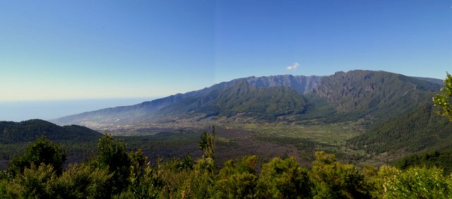
The Caldera de Taburiente is the fascinating centre of the island. This crater is the biggest depression in the world. It was formed through erosion and it surrounded by a circle of peaks starting from 1700 to 2400 metres high. Also here you can find the highest point in the island the “Roque de los Muchachos”, which is 2416 metres high. The crater is uninhabited and the only way you can travel in it, is by foot. You can only arrive and travel up through the narrow “Barranco de las Angustias”. In 1954 it was declared the National Park of the Caldera de Taburiente. La Palma is 3 million years old which is still relatively young. Some of it’s volcanoes are still active and these you can find in the south of the island. The last eruption was in 1971 in the Fuencaliente region, now know as Los Canarios. The evidence of all the eruptions are – cones, craters and kilometres of solidified lava – which gives a unique character to the south of the island.
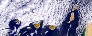
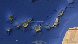 La Palma is part of Spain and is situated in the Atlantic ocean some 400km from the north-east of Africa and is at the same height as the Sahara. On a map you can see that in the north-east the coordinates are 28,5 degrees north in latitude and 18 degrees east in longitude. La Palma is one of the smallest of this cluster of islands, only El Hierro and La Gomera are smaller. It is only 726 kms square, and La Palma has almost unimaginable heights. The island has an extension of 47km long from north to south and 29 km wide from east to west. The island elevates from almost 4000 metres deep to 6500 metres. So in relation with the surface of La Palma it’s the highest island in the world.
The Climate
The old Greeks named La Palma ” The island of eternal spring”. Because of the climate and thanks to its southern latitude there is an equilibrium all year. Extreme temperatures in the Sahara nearby are calmed by the currents and the winds surrounding the Canary islands. In the winter months the temperature on the coast usually doesn’t drop lower than 18 C, and in summer the temperature fluctuates between 21°C and 24°C so the climate is very comfortable. It is only hot and dry when the african weather comes from the south east, this does not occur regularly and only happens a few times in the year and doesn’t last for long. When the hot winds come from the Sahara it is warm and it brings a fine red dust, we call this the ” Calima”. So its not cloudy but there is a constant mist around, in the summer it can take the temperature up to as high as 40 C for a few days.
 La Palma is divided into 2 regions because of the “Cumbre Vieja”. There is a necklace of cones and volcanoes from the north to the south and this causes two different climatic zones. Because of the wind from the north east, the south east part of the island has more sun and less rain than the north east. Generally these winds determine the climate of La Palma, in winter from October to April the situation is different : When the Atlantic winds from the west disperse, it rains in the west and the east is dry, although this never lasts longer than a few days. On the cost you can generally say for every 100 meters in altitude the temperature drops 1 grade.